So, what is happening now? What's being done about it? From the information I've found, not much and not enough.
One problem that can divide ideas and cause people’s attention elsewhere from an issue such as this, is money. Making the necessary changes to sustain our future can be expensive.
Property value is a high interest, for property owners, real estate businesses and the town’s Council. Every ten years, a new district plan is formed and a newspaper, The Mercury Bay Informer, on 18 February 2014 showed that a new district plan is being formed and submissions for it closed on March 14. The Council can now decide what to do, whether to oppose or support the plans.
The article mentions coast erosions, stating that there are two lines: a current coastal erosion line (CCEL) and a future coastal protection line (FCPL). New buildings are preferred not to be on the seaside of the CCEL but there was a comment stating that there is a 1% chance each year of erosion reaching the line. The article says that the area between the CCEL and FCPL is at risk due to sea level rise in the long-term, but not now. The article does show that there is some awareness of what is happening but it doesn’t feel like it’s enough, as it never states how much the sea level is rising by and focuses more on where they can place houses rather than talk about dealing with a problem that will continue to grow over time, possibly to the point where the houses they have placed will be dangerously close to the sea.
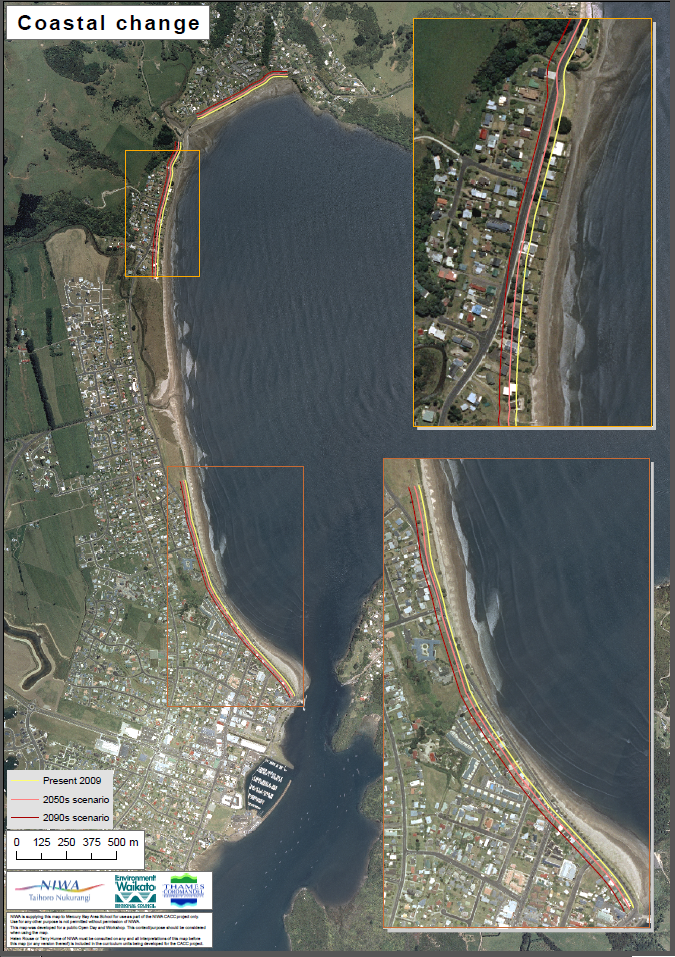
Image from 'Erosion Map' resource from NIWA
The graph above shows the lines for erosion on the Whitianga coastline. Yellow for present day, orange for 2050s, red for 2090s. the yellow line is further inland than the actual coastline but even so you can see that the road is mere meters from the beach. You can also see that those all three lines cross over areas of land occupied by houses. Imagine what the place could look like in a few decades, it is possible those houses be centimeters from the where the waves crash on the beach.
Another thing to consider is the lay of the land. Where the yellow line is is roughly the highest point of the beach after it, most of the surface area goes downhill. Imagine what would happen if the sea level rose to the point where is would be at the top of the hill and then it would fall down the back, onto the road, into houses and generally make the environment an unsuitable place to live.

There are a significant number of houses on the front of Whitianga’s beaches (Brophy’s and Buffalo beach), while many love a good view of the beach and being close enough to walk to it, the location of these houses is dangerous. Those properties will lose value, should some realize that they are threatened with rising sea levels. There is a possibility that one day these houses will no longer be safe to live in.
In Whitianga, there has been recent development on the beach front with rocks being placed to support the eroding coastline (as well as more pavements). This is a nice comprise and may even work for a while but eventually the tides will take away more sand and it is possible that the rocks will become unstable.
Another thing to consider is the lay of the land. Where the yellow line is is roughly the highest point of the beach after it, most of the surface area goes downhill. Imagine what would happen if the sea level rose to the point where is would be at the top of the hill and then it would fall down the back, onto the road, into houses and generally make the environment an unsuitable place to live.
There are a significant number of houses on the front of Whitianga’s beaches (Brophy’s and Buffalo beach), while many love a good view of the beach and being close enough to walk to it, the location of these houses is dangerous. Those properties will lose value, should some realize that they are threatened with rising sea levels. There is a possibility that one day these houses will no longer be safe to live in.
In Whitianga, there has been recent development on the beach front with rocks being placed to support the eroding coastline (as well as more pavements). This is a nice comprise and may even work for a while but eventually the tides will take away more sand and it is possible that the rocks will become unstable.
Some of you might look at this steady increase and think “But it’s not going to happen for a century.” or “But 1 metre isn't that much.” or “But it’s not my problem.”
It is our problem. It is a global change so it affects everyone. We can’t just leave it to the next generation to deal with and fix, thinking that it won’t affect us in our lifetime, because it will.
No comments:
Post a Comment